Day Four
09-02-04
We rose early and hit the road in semi-darkness. I must say that it had begun to dawn on us that though our journey was progressing delightfully, it was not progressing in a way that would insure our arrival at Fort Bowie before necessity would compel our steeds to turn tail and head for the barn. I fault myself for missing some of the stations by sheer obliviated inattention but
many stations required considerable leg work on location and a good bit of luck. One could easily spend half a day visiting with locals looking for the right person to guide you to a remote ruin. As I mentioned the stations themselves are well described for Oklahoma. A fabulous resource can be found on line at “The Chronicles of Oklahoma Volume 11. No. 2 -June, 1933.
Entitled, “Historic Places on the Old Stage Line from Fort Smith to Red River,” it was written by Muriel H. Wright around 1930. The stations and their locations are detailed in much better fashion than the locations we searched for in Missouri and Arkansas. I feel sure that any effort to locate precise coordinates for these locations would be rewarded.
There were over 13 such locations for us to discover in Oklahoma. What we decided to do was to use these locations to better define the route and in so doing keep us in the general topography of the trail; the same hills, the same creeks and rivers, the same seemingly endless path. Of course, whenever possible, we would take photographs of the station ruins we could find and the reminders of the past we would encounter along the way. In this way, from the open air of our motorcycles we could approach the sights, the sounds and the overall sensation of connecting with what was the spirit of this earlier magnificent endeavor.
Our next stop was Mountain Station. It was not far from Wilburton. It was actually a relay station on top of Blue Mountain and was said to be near Mountain Station Cemetery. There was
a cemetery marked at the top of Blue Mountain on an unnamed rode heading southwest towards Higgins, Ok. The cemetery was not hard to locate N34° 50.223'W95° 25.415'
The stop was placed well for relieving the horses after a long pull to the top.
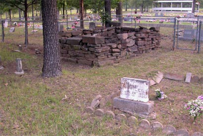
This ruin was right in the middle of the Cemetery. There was no sign saying what it was but this was called Mountain Station Cemetery. Certainly it looks old enough to be part of the station. The name on that tombstone was Andy Riley and he was only two years old when the first stage came through. He lived until 1939.
Pusley’s Station, was next. We had good information on the location of Pulsey’s , N34° 50.223'W95° 25.415' Silas Pulsey was granted the privilege of erecting a bridge and establishing a tollgate on Gaines Creek near his residence. What is known as the Old Pusley Place is just south of this crossing. A small branch of Gaines Creek near the farm still bears the name of “Pusley Creek” Worn ruts of the former stage line road can still be seen on the farm (1930) , an old well, a portion of an old log house, and the Pusley family burial ground can still be seen on this farm. Some of the older graves are unmarked, others have marble tombstones bearing the names of Pusley and Seeleys. The farm is near the present site of Higgins. The District Blacksmith shop was located here. There is also supposed to be a Historic Marker here.
Paul and I discussed this stop near the bridge past Higgins, but the road in was tertiary and the location, though described, was uncertain on the map. Further, once off the road there was also no clear continuous route through Ti valley, which was where the Butterfield went. We opted for paved roads to Hartshorne. At a liquor store there the proprietors were enthusiastic in confirming our decision. Buffalo Creek road through to Ti valley was nearly nonexistent and gated.
At Haileyville, we got confirmation on using SR 63, which pretty much turned out to be gravel but it took us into Blanco. A woman at the post office cautioned us against trying to snake our way into Ti valley from there, so we also missed Blackburn’s Station. I believe looking at the map that might have been a mistake because the “road “ clearly cuts through to Pine Top which is right near Blackburn’s Station.
Blackburn’s Station, N34° 40.935'W95° 44.354' Casper Blackburn’s was 16 miles from Pusley’s. East of the Colbert Crossing on Brushy Creek. By the side of the road a few hundred yards east of the crossing at Brushy creek is an old cemetery with a number of graves some of which are enclosed by sandstone walls. About a half mile northeast of this burial ground, the traces of the stage line run past an old house site near Elm Creek said to have been the location of Blackburn’s station. . Blackburn was an inter-married Choctaw. There is also a Historic Marker here according to the list.
From Pinetop the trail headed south then West towards Wesley. Of course, we didn’t go that way but I think you could. I calculate that it would have added about 6 hours to take those unimproved roads on bikes. Perhaps, we made the right decision after all.
What we did do was go on to Pittsburg and there took secondary roads south until we met up with the trail on the other side of Limestone Ridge. It was a neat ride but I think it was no easier than the road south from Blanco would have been and we might have seen Blackburn’s.
Beyond Wesley we continued southwest and stopped overlooking the valley that should have contained Waddell’s Station.
Waddell’s Station , N34° 34.480' W95° 55.990' (16 miles from Blackburn’s). Two miles west of Wesley to the north side of the road, near the head of McGee Creek is an old hewed log house, now known as the Beale Place. This site would have been thirteen miles from Geary’s Station at the crossing of Little (or North) Boggy. The Beale Place was the location of a Stage stand after the War. (Later known as Roger’s Station ). Paul and I could see no sign of the structure at least from the road.
We followed through beyond this stop and wound our way into the Atoka State Game Refuge. Wild and wooly it was, too. And long. We knew we were on the right road when we hit this sign. It said “Butterfield” and led to the back way into Stringtown. We hit the
highway and passed Geary’s Station. It took Ormsby three hours to get to Geary’s from Waddell’s. It took us nearly two.
Geary’s Station, N34° 34.480' W95° 55.990' 13 miles from Waddell’s. At the crossing of the Old Road, A.W. Geary was granted the privilege of constructing a bridge and establishing the tollgate over the Little (North) Boggy. He established his residence and extensive farm and other improvements at an early date. Geary is now inundated by the Atoka Reservoir. I noted the existence of a cemetery that is marked under the water and used it for the coordinates.
Throughout the years the portion of the trail between
Fort Smith and Clear Boggy River was generally known as the Fort Smith-Boggy Depot Road. With the establishment of Fort Washita in 1842 as a permanent military post and the extension of the road to that point, it was also sometimes called the Fort Smith-Fort Washita Road. The road struck the Texas Road about a mile north of present Stringtown, in Atoka County; thence the two roads merged to the Red River. Thus, for travelers both from the north and east toward Fort Washita the crossing on the Little Boggy about two miles southwest of present Stringtown was an important point.
We headed into Atoka and on the outskirts stopped at the Confederate Museum and Trace. This was a delightful and informative stop. I know I lingered overly long here for Paul’s patience. 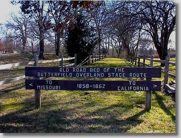 Besides a well preserved section of the Butterfield Trail there were many interesting exhibits concerning the Butterfield, especially Boggy Depot Station. Besides this they had this fabulous magazine like book that was published in concordance with the Butterfield Centennial in 1958. Published in Van Buren the title said, PRESS ARGUS- Van Buren Arkansas, Sept. 19, 1958. The Title says the Press Argus is ’ “Oldest Weekly Newspaper”
Ruie Ann Park was editor of the history page and compiler of this special Centennial Edition
Hugh Park Editor & Milton Willis, Gen. Manager.
This book had very valuable descriptions of the Stations through out Missouri and Arkansas and continued with stories and Newspaper clippings and interviews with individuals about the particular stations. I wanted to steal it, consume it or at least read it but the road was calling. I got the name of the museum director and promised myself that someday I would either find my own copy or come back and look again. Why we didn’t take digital photos of every page I’ll never know. We climbed aboard the horses and headed for Boggy Depot instead. You see we had another pressing concern. We had to be in Plano, Texas that night and we were still a long way from Plano.
Plano was not a regular stop on the Butterfield. Far from it. It was however, a necessary stop for us. Paul’s brand new Yamaha 1100 had to be serviced at 500 miles or the warranty would be voided. Accordingly, we had set this little appointment up in advance. Therefore, the pressing concern.
Boggy Depot Station, N34° 19.240' W96° 18.466' The heirs of the late William R. Guy were granted the privilege of erecting a bridge across Clear Boggy River and establishing a tollgate near their mill. Mr. Guy had married Jane Mcgee of the Chickasaw Nation and during the early 40’s and was first postmaster at the Depot in 1849 where he also kept an Inn. It is located at Boggy Depot State Park.
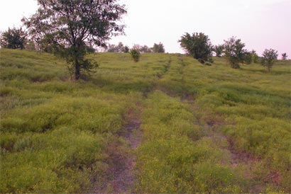
Getting there required some heading off the main road and eventual back tracking but we had missed some stations and we knew exactly where this one was.It did have more meaning after seeing some of the items excavated at the site. Originally we had planned to camp here. It would have been a good time to stop, anyway. Plano called. Below is a picture of the Boggy Depot site and the Butterfield road going off north into the timber.

It might be informative here to comment on the nature of the toll bridges that marked each of these stations. They are as they sound to be, the precursors of our modern toll highways. Each vehicle, horse, cow, pig, and person was charged a fee for the use of the bridge and the amenities of passing through the station. The Choctaw and Chickasaw Indians were no strangers to the advantages of establishing “highways “of transportation and taking advantage of the opportunities associated with the commerce of travel.
Regarding the Fort Smith to Old Boggy Depot Road: “It should be noted that the good roadbeds in the valleys, shallow crossings on the larger streams and easy passes through the outlying ridges of the San Bois and Winding Stair Mountains lay along this same line, which made it the best and most direct route for travel from Fort Smith across the Choctaw and the Chickasaw country to the Red River and points southwest. So it was a natural trailway undoubtedly followed by the native tribes and by visitors to the country lying between the Arkansas and Canadian and the Red rivers long before the first permanent settlements were established in that region.”
“In the beginnings of recorded history of Oklahoma, the road first came into prominence when it was traveled by the Chickasaw on their long journey in 1837-9 from their ancient homelands east of the Mississippi River.”
“However, both the Chickasaws and the Choctaws had long known the advantages of having permanent highways through their domains. With the establishment of the famous Natchez Trace (1802) out of Nashville, Tennessee, through the two nations to Natchez, Mississippi Territory, and the opening up of other highways in that region, a number of enterprising citizens among the Chickasaws and the Choctaws established their residences along them not only for the benefits to be gained from the traffic and travel that would pass their doors but also to have an easy access to ports of trade for the products of their own farms. Among these prominent Indian Families who had their homes on the early day highways in Mississippi were the Colberts, Loves, Folsoms, McKinneys, Holsons, Smallwoods, LeFlores, Juzons, Nails, Perrys, Harkins, McCurtains, and Pusleys.”
“Toll gate privileges were granted under legislative action to those Indian citizens who guaranteed to construct and maintain bridges and turnpikes over the larger streams and along the more difficult portions of the roads. The operation of its California stages by the Butterfield Company through the Choctaw and Chickasaw country was of such importance that the Council and the Legislature of each nation, respectively, granted eight of these privileges along the road from Fort Smith to Red River. The rates of toll in each instance, as granted by the Choctaw Council, were as follows: “
"For each four wheeled wagon, or other vehicle, drawn by four or more horses, mules, or oxen with driver, the sum of Fifty cents; For each four wheeled wagon, or other vehicle, drawn by one or two horses, mules or oxen, the sum of Twenty-five cents; For each man and horse, the sum of Ten cents; and for each animal in every drove of cattle, horses, mules, logs, or sheep, One cent." Chronicles of Oklahoma.
Of course, there were also agreements about the maintenance of the road that facilitated the flow of this traffic. In the Indian Territory, Bogey Depot was also the converging point for several of these trails to different points west and south.
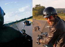
It was a killer road from Boggy Depot State Park to Highway 48. Dusty and long. Poor Paul had been assigned the rear position due to the fact that he had mounted the GPS to the bike I was riding. This was regrettable for many reasons. The first and foremost, of course, was that he ate my dust for about 1500 miles. Secondarily, I was GPS impaired from lack of familiarity with the technology. This resulted in me going in the wrong direction on numerous occasions as I tried to pilot my bike and stare into the sun-glared screen of the GPS at the same time as I was looking for any evidence of these elusive stations.  Going the wrong way also meant sudden, sometimes dangerously quick stops, u-turns and insane maneuvers on busy highways. His most constant concern was having a wreck, not with other cars, but by slamming into the back of me during one of my unannounced about faces. He learned to anticipate my confusion and to stay at least 300 yards to my rear. For my own safety he had to depend on the Our Lady of Guadalupe magic that Judy had sewn into the lining of my jacket. It was his safety he had to take most seriously and do something about.
Once on Highway 48 we slowed at the Blue River. It was wooded on the east side and no helpful pullouts.
Nail’s Station, N34° 5.326' W96° 21.754' Jonathon Nail had set up a mill at this crossing on Blue River early in the 40’s. Later erecting a handsome residence and a large store near the toll bridge and mill. East side of Blue River about two miles southwest of Kenefic. I couldn’t really tell where the old road crossed the creek and there doesn’t seem to be any structures near the new bridge.
We continued and when we hit 69 Highway we cruised straight through Durant and basically just waved at the next station, Fisher Stand or Strand. It was only a mile and half away from 69, I would guess.
Fisher’s St(r)and N33° 58.121' W96° 26.564' by the description that follows from the Chronicles:
(Carriage Point a name applied in the 60’s) Four Miles west and a little south of Durant. Said to be located north of the head of Island Bayou.
Next Station:
Colbert’s Ferry, N33° 49.133' W96° 31.362' Frank (B.F.) Colbert one of the wealthiest citizens of the Choctaw nation was granted the privilege of establishing a ferry across the Red River in regular session of the Chickasaw Legislature in 1858.
Franklyn Street heading south off of 69 is probably a good approximation into Colbert. Certainly Franklyn Road (Old River Road or 7A) headed south to the Red River would be a good guess. There is even a Butterfield road marked near it and a discontinuous road that picks up on the other side of the river. Pretty Cool. We of course did not go down there just to see the river but stayed on 69 into Dennison and on to Sherman.
Sherman Station, N33° 38.142'
Sherman was a wonderfully historic town. We found the historic Courthouse and the museum at the Carnegie Public Library. The Museum was very interesting and the curator there gave us directions to a historic marker in town.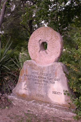
I remember this marker. It was adjacent to a busy street and we pulled to the curb for a picture. While Paul was taking the picture I heard a crunching sound and turned to see the 750 ass-in-the-air and rushed to upright her. Paul was very forgiving. I mounted the steed, no worse for the wear, and rode off towards Highway 75. Though the Butterfield followed 56 west, which roughly traces the “Marcy Trail,” we were obliged to detour south.
Highway 75 was very intense. We really hadn’t been up to Interstate speeds in some time and the rush of traffic through the very hot late afternoon temperatures was quite the re-entry into the modern world.
Fifty miles later we found a motel in Plano near the Yamaha dealer. Our cold beer run seemed especially important that night. It had been another very long day. Unfortunately, for Paul it was going to be a very early wake-up call. I, on the other hand, contemplated the pool.
posted by Don and Paul Matt at 12:23 PM
2 comments
![]()